
CCRIUD
For each census, the CCRI provides the user with location information for dwellings/households/individuals, with the boundary files to which location codes refer, and with some reference aggregate data from published census returns. The basic spatial unit for those three types of information is the Census subdivision (as listed in the published census returns) and is given by the CCRIUID (CCRI unique identifier), which allows us to link them together.
1) The unique geographic identifier (CCRIUID)
The CCRIUID is the unique 10-character geographic identifier which is used for geocoding. It is an alphanumeric variable based on the Census division (CD) and subdivision (CSD) numbers as listed in the published tables. For each census year, the table with the most complete listing of Census subdivisions was selected as the KEY table to establish the number of CSDs and their names. In general, the KEY table is the table containing male and female population counts, except for 1941 (population by ethnic origins).
Figure 1 gives an illustration of the key table for 1921, and the corresponding CCRI published summary data file. In this example, Alberta Division No. 1 is given the CD number of 189, because it is the 189th CD listed in the published table. The KEY table ID field, V1T16_1921, is the initial coding of the CCRIUID, which is then completed as below.
Figure 1. Published KEY TABLE used as basis for hierarchical coding of 1921 CCRIUID
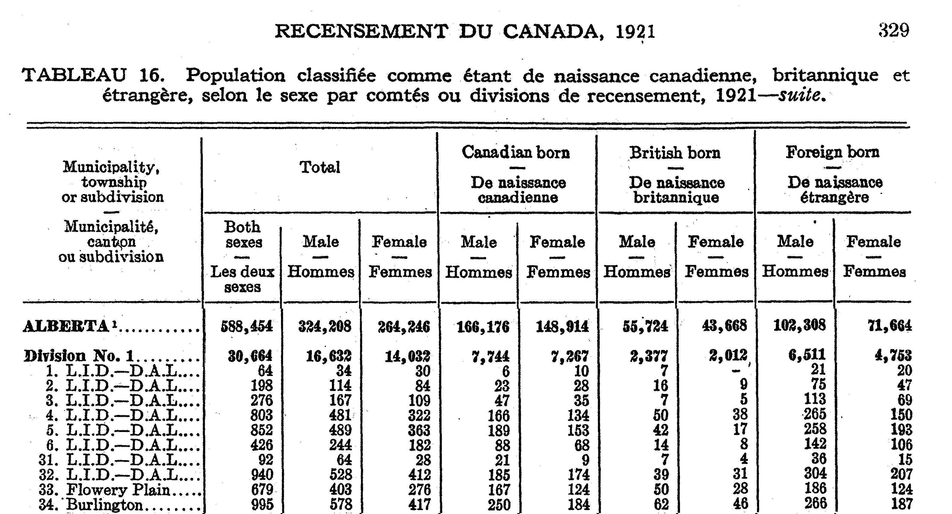
Top: Scanned section of original published KEY TABLE
Bottom: First 10 columns of CCRI published summary data file for same section
The CCRIUID field name always includes the census year to which it applies (1911, 1921, etc.). The unique CCRIUID_19YY is constructed by concatenation of the PROVINCE CODE,CENSUS DIVISION NUMBER, CENSUS SUBDIVISION NUMBER, CENSUS SUBDIVISION PART NUMBER, for each polygon, for each census year. See Figure 2, “Parsing the CCRIUID” for illustration.
Figure 2. Parsing the CCRIUID
PROVINCE CODE: 2-character code: AB, BC, ON, QC etc.
CENSUS DIVISION NUMBER: 3-character code: 001, 002, etc.
CENSUS SUBDIVISION NUMBER 3-character code: 001, 002, etc.
CENSUS SUBDIVISION PART NUMBER 2-character code: 01, 02, etc, where applicable. 00 when not necessary. See explanation in text.
CCRIUID_19YY eg: AB18900100
This hierarchical coding system is mostly self-explanatory, and seeks to duplicate the structure of the reporting of the census as represented in the published KEY table.
NOTE: There is one point that needs special consideration since it is not derived from the published KEY table: the SUBDIVISION PART NUMBER. The SUBDIVISION PART NUMBER is a constructed code which has been added for the purposes of geocoding. The CSD is based on a single line in the KEY table. Most CSDs have no “parts” (i.e. each represents an integrated uninterrupted polygon with no identifiably different geographic subdivisions). In these cases the PART code is not significant, and is set as “00”. However, if there are identifiable parts to the CSD, the parts are coded 01, 02, 03, and so on. There are a few common situations where this occurs:
* CSDs listed in the KEY table as two or more townships or parishes combined, eg: “Joe and Bob Townships”, where these are found to be separately identified in the census manuscript
* CSDs listed as “Other parts”, where these other parts are found to be identifiable geographic units such as surveyed townships, in the census manuscript
* CSDs listed as Indian reserves, where individual reserves are found to be identifiable in the census manuscript
* CSDs on the Prairie provinces listed as Municipalities or Improvement districts, but separately identified as numbered townships (Township, Range, Meridian) in the census manuscript
These “parts” have been kept separate in the construction versions of the CCRI GIS data layers for the development of the GIS infrastructure in the future. They have been merged into multi-part CSD polygons for the immediate purposes of exporting the shape files at the CSD level. Researchers interested in using the more detailed construction version should apply to the CCRI distribution network for access.
One point must be reiterated: there is a difference between the manuscript census organization and the published census organization. The latter is the basis for the CCRIUID, while the former is transcribed on the manuscript schedules. This must be clearly understood because the images of the manuscript enumeration census schedules are now available online for 1911, and will become available for 1921 and subsequent years as the 92-year confidentiality period expires for each census. Care must be taken not to confuse these two geographical organizations, as they both utilize the terminology of “District” and “Subdistrict”, but are completely different. Both sets of identifiers are included in the microdata sample files, but only the CCRIUID-derived geographic identifiers should be used for the geographic selection and depiction of data since only they can link the dwelling/household/individual to 1) the actual spatial unit where they lived; 2) the actual spatial unit in which they have been compiled for published returns; and 3) the polygon created for the mapping and spatial analyzing of CCRI data.
If research must be done with the census-taking geography information, as appearing on the manuscript schedules (and digitized by CCRI data entry operators), it must be remembered that those variables (schedule header geographical information such as province, enumeration district and enumeration subdistrict; manuscript individual place of adobe) are delivered as they are, without having passed through any cleaning/standardization/coding process.